Skip to content

Haloglide Scout

Every plot verified. From orbit.

You cannot walk every farm in your supply base, every season. Scout can. It checks the land behind every product from space, and turns what it sees into evidence a buyer or regulator can open.

Cultivated fieldFarm buildingsAccess road
Soil pH

Acidity and alkalinity

Vegetation greenness

Canopy condition

Soil moisture

Water available to crops

Rainfall

Growing conditions

The smallholder problem

Start with a GPS pin. Understand the farm before you visit.

Start with a location. Scout helps you map fields, buildings and access roads, then assess farming activity, growing conditions and crop viability. Get a clearer picture of your supplier before committing to supply or planning a visit.

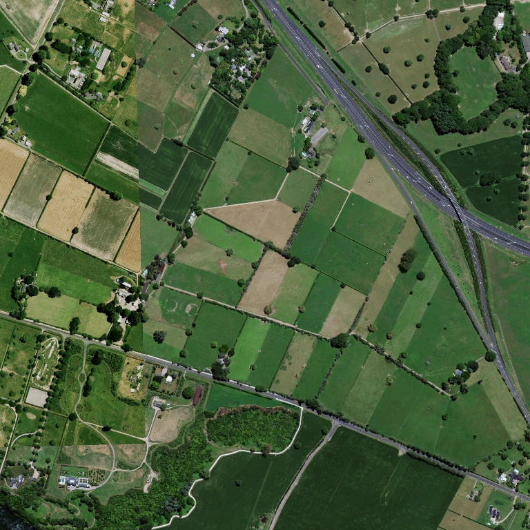
Real aerial imagery of agricultural fields in Waikato, New Zealand

Step 1

Pin

A GPS point from a phone

Real aerial imagery of agricultural fields in Waikato, New Zealand

Step 2

Farm reconnaissance

Map the fields, buildings and access before you visit.

Real aerial imagery of agricultural fields in Waikato, New Zealand

1 · Cultivated field

2 · Farm buildings

3 · Access road

ViableFunctioningNext check in 6 months

Step 3

Intelligence analysis

Understand farming activity, crop viability and the evidence behind the claim.

Four mission types

Ask the land a question. Get an answer you can defend.

01

Deforestation Check

Has this land been cleared since the EU cutoff?

Built for EU Deforestation Regulation due diligence. Scout checks each plot against the 31 December 2020 cutoff and records the result against the location and the lots it supplies, ready for your due diligence statement.

  • Checked against the EU cutoff
  • Works on boundaries or GPS points
  • Never clears a farm without evidence
  • Linked to lots and statements
See the EUDR toolkit
02

Land Use

Is this a working farm with viable conditions for your crop?

Build a supply base you can trust. Land Use checks farm existence, recent activity, operational viability and whether the evidence matches the expected crop. Vegetation, moisture, rainfall and fire evidence help you identify farms that need support or a closer review before you commit to supply. Apply the level of evidence your sourcing policy requires consistently across suppliers. Available by arrangement.

  • Verify farms before sourcing
  • Confirm recent farming activity
  • Assess viability and crop fit
  • Focus visits where they matter
03

Land Insights

What can this land support, and what could put your supply at risk?

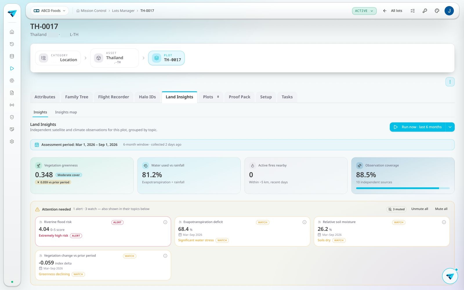
See soil properties, canopy health, water availability, growing conditions and more in one report. Compare plots, identify signs of crop stress and give buyers evidence behind your environmental claims. Choose the insights relevant to your crop, sourcing decisions or assurance programme.

  • Understand soil and canopy health
  • 195 available data points covering water, soil, climate and more
  • Compare growing conditions
  • Support buyer and audit evidence
04

Fly Over

Map with confidence. See what is on the land before you visit.

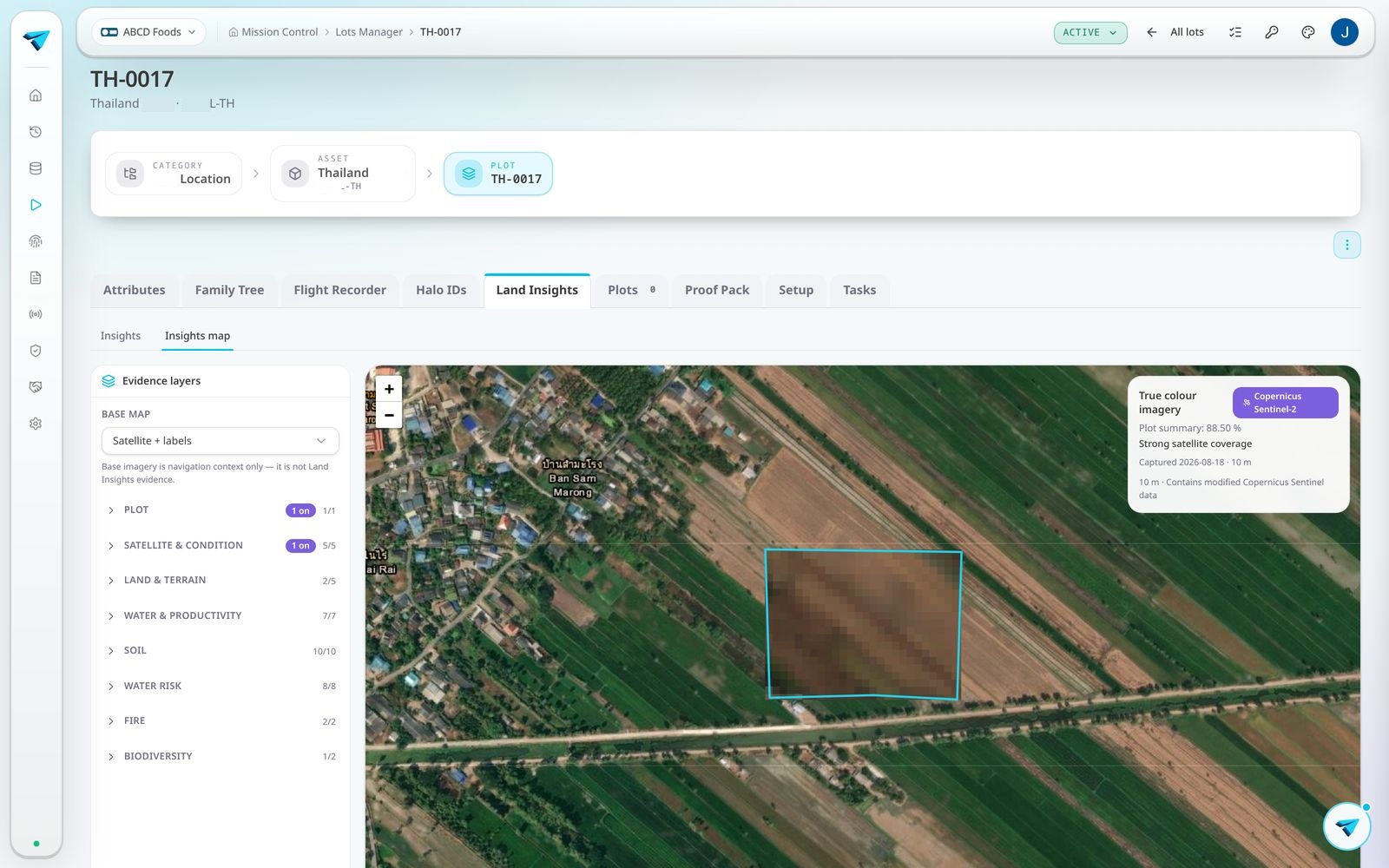
See planted areas, buildings, roads and water within your supplier's plot. Fly Over turns imagery into a labelled map so your team can check whether supplier records reflect what is on the ground, understand access and plan more focused visits. The mapped features also strengthen the evidence that this is a working agricultural site.

  • Check supplier records against the land
  • Locate planted areas and infrastructure
  • Plan access and site visits
  • Strengthen farm verification

Clear outcomes. Confident decisions.

Compare suppliers on a consistent evidence basis. See which claims are supported, where a concern needs attention and where to gather more evidence. For Land Use, align the evidence required with your sourcing policy so your team can make consistent decisions across the supply base.

Verified

The evidence supports the claim.

Not verified

A concern is identified so your team can investigate.

Inconclusive

Gather more evidence before making a sourcing decision.

Know your soil. Understand your canopy. Protect your supply.

Choose the land insights that help you make better sourcing and grower support decisions. Available insights depend on the location and assessment period, with coverage explained in the report.

Soil properties

Soil pH, organic carbon, nitrogen and texture help you understand what the land can support. Modelled estimates guide where to investigate, not replace soil testing.

Canopy health

Vegetation density, greenness and canopy moisture reveal signs of stress or recovery, helping you prioritise grower support.

Water and soil moisture

Rainfall, water consumption and soil moisture help you understand whether crops are getting the water they need.

Growing conditions

Temperature, rainfall, humidity, sunlight and wind put a good or difficult growing season into context for buyers.

Biomass and water productivity

Plant growth and growth per unit of water help you compare how efficiently plots turn water into production.

Fire and disturbance

Evidence of burning, clearing or sudden change helps you focus due diligence and protect sourcing commitments.

Land cover

Cropland, plantation and forest classifications help corroborate the land use declared by your suppliers.

Terrain

Elevation, slope and slope direction help you understand drainage, erosion exposure and access before a site visit.

Water risk

Regional water stress, drought and flood indicators help you assess exposure across your supply base and plan a closer review.

Biodiversity

Recorded species on and around a plot support nature related reporting. These are documented observations, not a complete species inventory.

Official designations

Check for overlap with published protected areas, wetlands and hazard zones to focus land due diligence. These checks are not a legal determination.

Scout Land Insights report in Haloglide Orbit

One farm or your whole supply base. Then again next quarter.

  • Review your supply base together. Check multiple farms in one run so your team spends less time organising individual assessments.
  • Keep sourcing evidence current. Repeat checks monthly, quarterly, six monthly or yearly without rebuilding the assessment each time.
  • Compare suppliers consistently. Reuse the same crop, assessment period and chosen insights across farms and repeat checks.
  • Give buyers proof they can open. Share a report without asking the buyer or certifier to log in, and withdraw access whenever you choose.
Plot map in Haloglide Orbit

Know your land. Back your sourcing decisions.

Every check is saved against the location and the lots it supplies. Collect it once, and use it for every buyer and standard that asks.

Book a demo

Images and examples show demonstration data. Farm imagery © Esri and its imagery contributors.